

Caesarea Static Air Bridge Site Plan
Engineering Site Plan for CAESAREA airport.
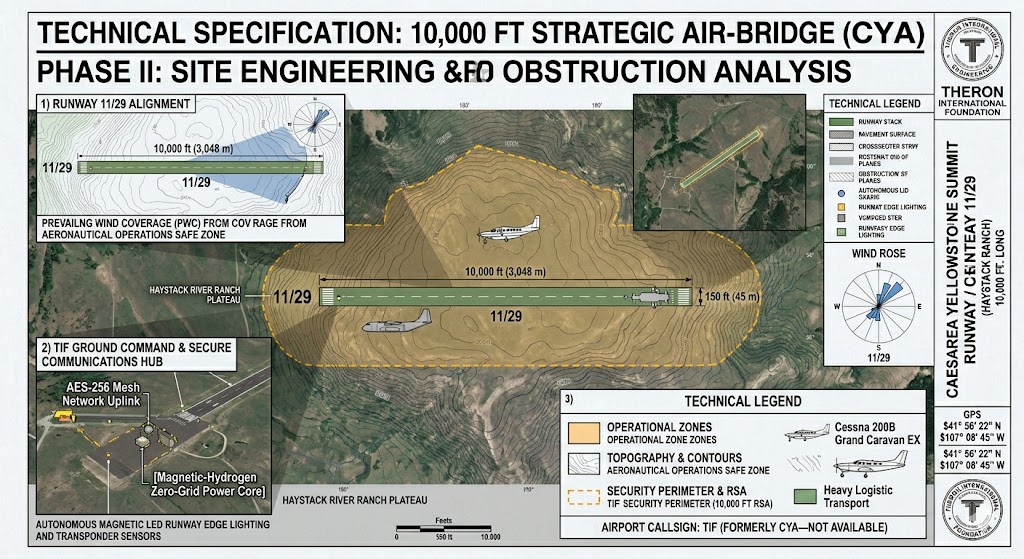
Phase II: Topographic Analysis & Obstruction Survey
Project Code: TIF-ALPHA-WY Facility Class: Strategic Heavy-Lift / Private Sovereign Hub Runway Designation: 11/29 (Primary)
1. Topographic Advantage & Site Selection
The Yellowstone Summit was selected following a rigorous terrain analysis of the Haystack River Ranch plateau. At an elevation of 7,150 ft MSL, the site provides a natural “High-Ground” security perimeter with 360-degree visibility.
Gradient Analysis: The plateau offers a naturally level 12,000 ft stretch, allowing for a 10,000 ft primary runway with minimal earth-moving requirements, preserving the natural ecological footprint of the ranch.
Thermal Lift & Performance: The 10,000 ft length is a strategic requirement for high-altitude operations, ensuring that heavy cargo aircraft—transporting Theron Energy infrastructure—have sufficient accelerate-stop distance during high-density altitude conditions.
2. Obstruction Clearance & Safety Planes
Our Phase II study confirms that the Runway 11/29 alignment is clear of all natural and man-made obstructions within the Aeronautical Operations Safe Zone.
Approach/Departure Paths: The glide slopes for both thresholds are unimpeded by the surrounding ridges, allowing for safe VFR and future IFR (Instrument Flight Rules) operations.
Prevailing Wind Coverage (PWC): The 11/29 orientation is optimized for the region’s dominant westerly winds, maximizing crosswind safety margins for heavy-lift logistics.
3. Integrated Sovereign Infrastructure
This site plan incorporates the TIF Ground Command modules directly into the airfield perimeter:
Autonomous Lighting: Powered by the on-site Magnetic Zero-Grid core.
Secure Mesh Communications: The site serves as the primary uplink for the Caesarea AI Data Center, ensuring the air-bridge remains operational even if national infrastructure is compromised.