


TIF Master Airport Layout
Caesarea TIF Master Airport Layout Strategic Master Plan: TIF Logistics Hub (Phase III) Project: Theron International Foundation – Wyoming Strategic Reserve Design Inspiration: PBI...
Read More
Engineering Legend
Caesarea Engineering Legend Engineering Specifications (Legend) I. Strategic Heavy-Lift Capacity Design Service Goal: Support for the C-17 Globemaster III and Boeing 747-8F. Technical...
Read More
Strategic Air Bridge Site Plan
Caesarea Static Air Bridge Site Plan Engineering Site Plan for CAESAREA airport. Phase II: Topographic Analysis & Obstruction Survey Project Code: TIF-ALPHA-WY Facility Class:...
Read More
TIF Runway Blueprint
Caesarea Runway Blueprint Our private secure airport TIF, will be able to allow any major and small aircraft to land in emergencies. The runway...
Read More
Flight Operations
Caesarea Flight Operations Flight Operations & Safety Disclaimer Notice to All Aviators: The Yellowstone Summit (TIF) is a Private-Use Facility owned and operated by...
Read More
Statement of Filing & Technical Specifications.
Caesarea Statement of Filing & Technical Specifications “We are being transparent about our intent to comply with 14 CFR Part 157.” Project Title: Establishment...
Read More
Autonomous Infrastructure & Secure Comms
Caesarea Autonomous Infrastructure & Secure Comms Objective: To provide 24/7 operational capability at the Yellowstone Summit and remote project sites without human intervention or...
Read More
TIF Security Blueprint
Caesarea TIF Security Blueprint Strategic Asset: The Yellowstone Summit Security Blueprint I. Tactical Location & Topography The selection of the Yellowstone Summit for the primary...
Read More
Strategic Avaiation & Logistics: The TIF Global Network
Strategic Avaiation & Logistics: The TIF Global Network Strategic Aviation & Logistics: The TIF Global Network Overview: Sovereign Mobility in Uncertain Times The Theron...
Read More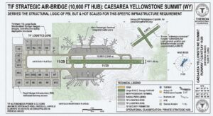
FAA filing for TIF
FAA filing for TIF The Intelligence Brief: Securing TIF Asset Requirement Strategic Advantage Location Identifier FAA Form 7480-1 Registering the physical summit as a...
Read More