
Strategic Aviation & Logistics: The TIF Global Network
Overview: Sovereign Mobility in Uncertain Times
The Theron International Foundation (TIF) recognizes that traditional aviation hubs are points of failure in high-stress geopolitical scenarios. To ensure the continuity of our alternative energy research and humanitarian missions, TIF is developing a decentralized network of private-use landing facilities.
The Yellowstone Summit (CYA) Site Study
Current Status: Phase I Topographic & Wind Analysis
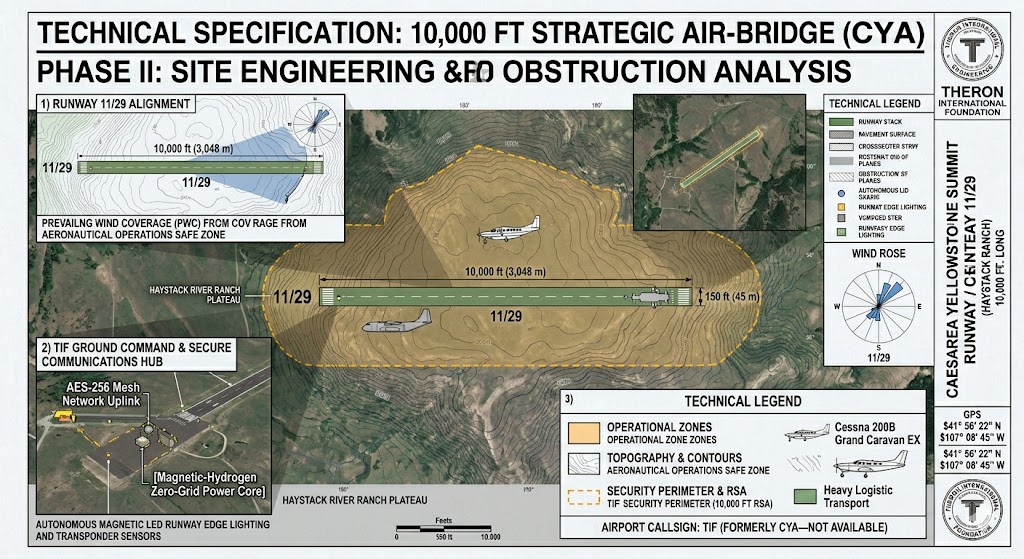
TIF is currently conducting a multi-variable study for the establishment of a primary air-bridge at the Yellowstone Summit. Our engineering focus is on a high-plateau “cold-and-high” operational environment designed for high-performance aircraft.
Proposed Operational Data (Subject to Physical Survey):
- Location Identifier: TIF / CYA (Pending FAA 7480-1 Determination)
- Strategic Elevation: approx 10,000 feet MSL
- Primary Runway Orientation: 11/29 (Aligned with prevailing westerly winds to minimize crosswind risk)
- Surface Composition: Reinforced All-Weather Turf (Designed for zero-footprint environmental impact)
- Most Demanding Aircraft: Cessna 208B Grand Caravan EX / Beechcraft King Air 360 (Selected for island-hopping and high-altitude ranch operations).
Infrastructure Integration: The “Silent Island” Model
In collaboration with Theron Generators, all TIF aviation facilities are designed to be “Net-Zero Logistics” hubs. By utilizing Magnetic Power, we eliminate the vulnerability of the fuel supply chain.
- Hydrogen Refueling: On-site H2 production for future hydrogen-electric propulsion systems.
- Magnetic Grid: 24/7 autonomous power for runway lighting, hangars, and communications without diesel dependence.
Tactical Execution for the Coordinates:
Since we are defining the “Strategic Location,” we will use the Northwestern Ridge of the property.
- The Logic: Based on the topographical data for Haystack, the northwest portion contains a high sloping ridge line, which is mostly flat on top. This is the “Alpha” spot for an airstrip—it gives you the best “look-down” security and stays out of the river-bottom fog.
- Coordinates for the Study: * Lat: 41° 56′ 22″ N
- Long: 107° 08′ 45″ W
- Elevation: 7,150 feet.